|
|
|
|
![]() Home
Home
![]() History
History
![]() Notice
Board
Notice
Board
![]() Contacts
Contacts

Harford County, Maryland was discovered in 1608 by Captain John Smith of the Virginia Colony (the same John Smith of the Pocahontas legend). He made a fairly accurate map of the upper country and its islands and shores. On this map, he designated many places whose names are still in use today.
The island now called Poole's, he named "Powell's Isles" after Nathaniel Powell in his crew. He named Willowbye's River (today's Bush River) after the town in which he was born and in honor of his friend, Lord Willowbye.
Smith proceeded northward from the Bush River, passing what is known today as Spesutia Island and Havre de Grace, and into the Susquehanna River. He traveled up the Susquehanna to a stream flowing from the northeast, which is believed to be Deer Creek.
The first settlement in the region was made by a young Englishman, Edward Palmer in approximately 1622. Having heard about the Smith exploration, Palmer decided to establish a fur trading post in a spot where he could trade with the Indian trappers to the north. This location, at the mouth of the Susquehanna, was also accessible by water to other trading posts on the Bay and rivers to the south. The name was changed to Garrett Island, in honor of the president of the B & O Railroad John W. Garrett, in 1885.
One of the first permanent settlements in the county was on Poole's Island, which was granted to Captain Robert Norris in 1659. About 1649, Col. Utie came from Virginia to explore the upper bay region and find a place to settle. In 1658, Bearson's Island, located a few hundred yards south of Havre de Grace, was granted to Nathaniel Utie. He changed the name to Spesutie, using the Latin Spes-Utie, meaning Utie's Hope. The spelling was later changed to Spesutia as it is known today.
Harford County had its beginnings as a part of Baltimore County, which was created in 1659 and included the territory of Baltimore, Harford and Cecil counties.
The first county seat, the town of Old Baltimore situated on the east bank of Bush River in what is now Aberdeen Proving Ground, was authorized in 1674. In 1712, the county seat was moved to "Gunpowder Town", located at Joppa on the east side of the Little Gunpowder where Joppatowne now stands. In 1768, after many difficulties in Joppa, including a smallpox epidemic, the county seat was moved to Baltimore.
Harford was not organized into a county until 1774. At that time the present territory was fairly well settled; the population amounted to thirteen thousand people. Roads had been laid out, bridges made, churches built and our progenitors lived in a peaceful and well-governed section as citizens of Baltimore County.
The Act of the General Assembly of 1773, called for the division of Baltimore County and for the erecting of a new one by the name of Harford, named after Henry Harford, son of Frederick Calvert, the last Lord Baltimore.
The boundaries of the county were established as follows:
" That part of Baltimore county which is included within the bounds following, to wit: Beginning at the mouth of the little falls of Gunpowder river, and running with the said falls to the fountain head, and from thence north to the temporary line of this province, and thence with the temporary line to Susquehanna river, thence with Susquehanna to Chesapeake bay, and thence with the said bay, including Spesutia and Pool's Islands, to the mouth of the Gunpowder river, and thence up the said river to the beginning aforesaid, shall be and is hereby erected into a new county, by the name of Harford county." In more common language, those boundaries are: The Pennsylvania state line to the North ; The Susquehanna River to the East ; The Chesapeake bay to the South; The Little Gunpowder River and a line due north from its source to the West.
The first court for the new county was held on March 22, 1774 at Harford Town, or Bush, located at what is now the junction of Route 7 and Route 136. In 1775, the citizens of Harford county passed "The Bush Declaration", becoming the first organized body of men in the country to proclaim independence from Britain.
After the Revolution, in 1782, an election was held to move the County Seat to Bel Air, where it remains to this day.
(Information courtesy of : Our Harford Heritage by C. Milton Wright, 1967 and Virtual Harford County web site).
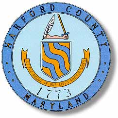
The Harford County Coat of Arms was designed by Mr. George Van Bibber and adopted by the County Commissioners on September 28, 1964.
In the accepted design the shield is gold to symbolize the wealth of the county and the richness of its fields. Across the shield are waving bends of blue signifying three major county streams - Deer Creek, Bynum Run, and Winters Run.
The crest is a two-handed forearm with the right hand holding escrivant, ( heraldic for "writing" ) a white quill symbolizing the pen used by those who wrote and signed the Bush Declaration. The left hand holds a sword as if presenting into the right hand of the nation the skills of reproducing defense materials, emanating from Edgewood Arsenal and Aberdeen Proving Ground.
The motto "At the Risque of Our Lives and Fortunes" comprises the last eight words of the Bush Declaration and preserves the same spelling for "risk" that is used in that document.
(Information courtesy of : Harford County web site).
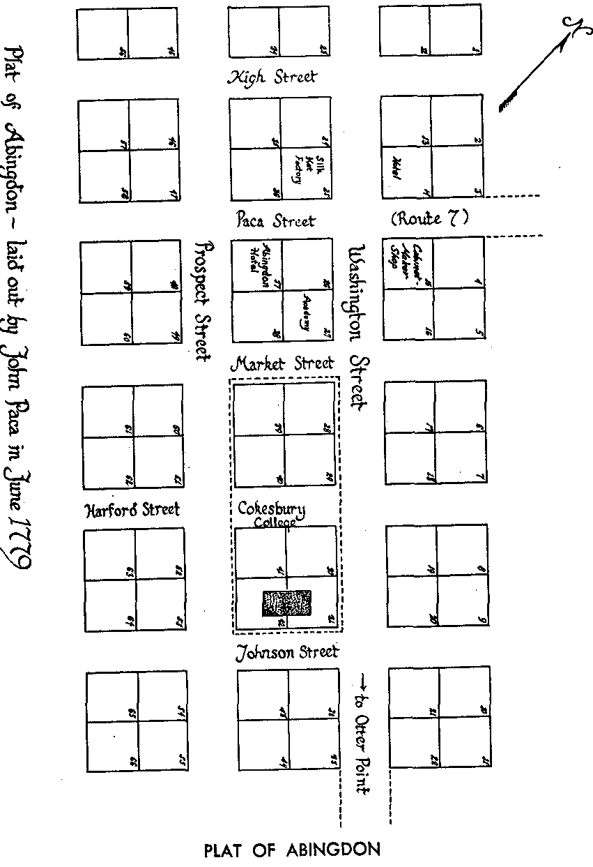
The town of Abingdon is one of the oldest in Harford County, having been laid out by the Paca family in 1779. It's name stems from an English town in an agricultural center of Berkshire, England. It is situated on the Old Post Road about two miles west of the former county seat at Bush. William Paca, who was born in 1740 at Chilbery Hall, the old Paca family home, was an important and influential citizen who had much to do with the founding of the early town as well as being a signer of the Declaration of Independence. He later built Rose Hill in the small village and lived there for several years.
John Paca did the actual laying out of the town, and his plat is recorded in the land records at Bel Air. This plat of sixty-six lots gives the names of the streets and the locations of the important buildings. Paca Street ran north and South and is now known as Old Post Road, while Washington Street formed the crossroads and leads to Otter Point. There were two hotels, one on the Northeast corner of Paca and Washington Streets, and the other on the south side of Paca Street. Cokesbury College, built six years after the plat was made occupied lots 28 to 42.
Abingdon was an outstanding town during colonial days and became not only a manufacturing center of note, but the home community of many citizens active in business, government and politics. Large landowners nearby included Aquila Hall, George Bradford, and Richard Dallam. These men played a leading role in the county's part of the American Revolution.
As a center of industry, Abingdon in former days probably outranked many other Harford towns. There were several silversmiths, among the most noted of whom were Joseph Toy, Isaac Nicholas Toy and William Wilson. All of these lived and plied their trade for many years after the founding of Harford in 1773.
The first silk hat factory in America was located at the northwest corner of Washington and Paca Streets. It was well known from 1800 to 1820 for the manufacture of high beaver hats, so fashionable in that day.
The town also had a gunsmith shop, a pottery, and three cabinetmaking establishments. As cabinetmakers and undertakers, the name McComas figured prominently from the early days. In 1808 John Clay McComas established the business near the center of town, and it has continued successfully in the family through four generations.
The town was also an educational and religious center, having been selected for the site of Cokesbury College, the first Methodist College in America. Two academies added to the educational prestige of the village. The Cokesbury Academy was under the jurisdiction of the college and continued for several years after that institution came to a disastrous end.
Abingdon also boasted of being the home of the first newspaper published in the county. In 1805 Daniel P Ruff established the ABINGDON PATRIOT, a small four-page weekly publication, which served for a number of years as a local news and advertising media for lower Harford. This paper is said to have published several valuable historical pamphlets about 1805.
Abingdon, originally an old village along the Old Post Road (Route 7) and Abingdon Road, is noted in local postal history for its straightline cancels, used 1830-1840. A new post office was opened two miles north of the old village to support a booming area of new homes. Two smaller local post offices (Sewell and Van Bibber) were merged into Abingdon between 1920 and 1930.
(Information courtesy of : Our Harford Heritage by C. Milton Wright, 1967 and Virtual Harford County web site).
Originally known as Laurentum (Latin for Laurel), the area now known as Box Hill, was an estate of some 300 acres and part of Constant Friendship, a tract of 1,000 acres. It was surveyed November 2, 1695 for a Mr. Robert Deans and was acquired prior to the Revolutionary War by Colonel Thomas White of Philadelphia. Around 1800, Laurentum was given by Colonel White to his daughter and her husband, Acquila Hall. Here, on the hill overlooking the Chesapeake Bay and the Eastern Shore, they built a stone house surrounded by the laurel and vast boxwood gardens. In 1881, Laurentum was again a gift, this time to Colonel White's son, William G. Hall. The property was partially destroyed by fire in 1920 and only the walls were standing when Laurence M. Simmons, Esq., of Baltimore, an investment banker and patron of the arts, took possession in 1926.
Among the remnants of Laurentum were several large boxwoods, vague reminders of a once beautiful garden. When he bought the property, Mr. Simmons renamed the estate "Box Hill". Using the original foundation of the stone house, Simmons constructed one of the most distinguished and totally unique homes in all of Maryland, choosing a combination of Georgian, early Maryland and old English architecture for his 15 room house. The living room with its unusual cornice is particularly attractive. The house contains 5 bedrooms, 3 ½ baths, maid's quarters and has 6 fireplaces, a formal dining room and a library.
The small stone and clapboard guest house built by the Hall family around 1780, called the School House, was at one time used as such by the many Hall children and those of neighboring families.
In August 1965, Bosely & Ward Enterprises purchased the Box Hill Estate with the surrounding 330 acres from the estate of Laurence M. Simmons. Today it houses the corporate offices of Art Builders, Inc.